Subtle changes in hydrology, topography and soil fertility can result in large shifts in floodplain meadow plant communities (Gowing, Tallowin et al. 2002). The soil-water regime and topography determine where different plant communities will grow. Soil fertility is also key; for example, the amount of available phosphorus of a Burnet Floodplain Meadow (MG4), is typically between 5 and 15 mg l -1 (Gowing, Tallowin et al. 2002). So, before exploring the options further, it is essential to collect information about soil type, structure and fertility, hydrology and topography through a site assessment, as this may reveal issues that will need to be addressed before restoration or creation can take place.
The soil-water regime and topography determine where different plant communities will grow.
Soil fertility is also key; for example, the amount of available phosphorus in the soils of a Burnet floodplain meadow (MG4), is typically between 5 and 15 mg l-1. See the table below for ideal ranges for restoration/creation in terms of soil fertility, pH, water levels and soil structure.
|
|
Ideal range for restoration/creation
|
|
Soil fertility
|
5-25 mg/l-1 P
|
|
Soil pH
|
pH > 5.5
|
|
Soil-water levels
|
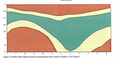
Roughly matching figure 3.3 ideal water-table depth zones
|
|
Soil texture and structure
|
Good soil structure (not compacted), soil profile indicates fluctuating water levels in appropriate zone
|
Follow our flowchart below to help with initial site assessment. Click on the images for a larger version.


Once you have gathered the information, use these tools to help you understand what it is telling you:
Soil-water data
Use our hydrology tool to help interpret dipwell soil-water data. This tool indicates, based on a choice of generic soil types, what the expected plant community based on recorded water levels is likely to be . Use this to help inform choice of seed source and as the project develops, to learn how the plant communities match the hydrological regime found.
Download the tool at the bottom of this page.
Soil nutrient data
What does the Olsen P result mean for my restoration site?
| Index |
Olsen’s P Range (mg/l) |
FMP Comments |
| 0 |
0-9 |
5-15mg/kg P is the range in which many species rich floodplain meadow sites are found |
| 1 |
10-15 |
So this range should be perfect for the typical floodplain meadow plant community. |
| 2 |
16-25 |
Species richness does decline above 20mg/kg, but it is still definitely worth having a go. |
| 3 |
26-45 |
>Over 25mg/kg it would be best to reduce the P level first through growing a barley crop with nitrogen added but no Phosphorus (if arable). If already grass, take one or two years worth of hay cuts and then re-measure soil P, as this is another way of reducing the P load. In heavy clay soils, it might take more than one year before P levels start to fall. Could also try an early hay cut (June) followed by a second cut in August/September to try and reduce the load. |
| 4 |
46-70 |
Values above 50mg/kg are probably too high to consider species rich grassland restoration on without drastic measures such as top soil stripping, deep ploughing or chemical amendment. |
Guide to floodplain meadows
Get a copy of our FSC ‘Guide to Floodplain Meadows’ and use it to help identify what plants you may already have on your site (if not arable). Use this information to tell you what your soil water regime and soil fertility may be (information found in the guide). Or see the plant grid here.
A plant species list
Use this plant list to help record what plants are present on the site, and to monitor changes as the restoration project progresses.